
Ang naging panayam ng NET25 “Mata ng Agila Primetime” kay Governor Doktora Helen Tan patungkol sa bagyong #KristinePH
Link:
https://www.facebook.com/QuezonGovPh/videos/1073344714575075
Quezon PIO


Link:
https://www.facebook.com/QuezonGovPh/videos/1073344714575075
Quezon PIO

WALANG PASOK BUKAS, Oktubre 25, 2024 sa mga tanggapan ng pamahalaan at sa lahat ng antas ng paaralan (pribado at publiko) sa buong lalawigan ng Quezon bunsod ng Bagyong Kristine.
Ipinauubaya naman ang pagsuspinde ng trabaho para sa pribadong sektor sa mga namumuno nito.
Manatiling nakaantabay sa mga ilalabas na anunsyo mula sa DOST PAGASA ukol sa lagay ng panahon.
Quezon PIO
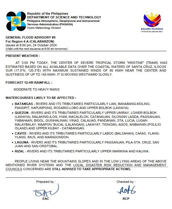
(𝐕𝐚𝐥𝐢𝐝 𝐮𝐧𝐭𝐢𝐥 𝐭𝐡𝐞 𝐧𝐞𝐱𝐭 𝐢𝐬𝐬𝐮𝐚𝐧𝐜𝐞 𝐚𝐭 𝟔:𝟎𝟎 𝐚𝐦 𝐭𝐨𝐦𝐨𝐫𝐫𝐨𝐰)
𝐏𝐑𝐄𝐒𝐄𝐍𝐓 𝐖𝐄𝐀𝐓𝐇𝐄𝐑:
AT 3:00 PM TODAY, THE CENTER OF SEVERE TROPICAL STORM “KRISTINE” {TRAMI} WAS ESTIMATED BASED ON ALL AVAILABLE DATA OVER THE COASTAL WATERS OF SANTA CRUZ, ILOCOS SUR (17.0°N, 120.3°E) WITH MAXIMUM SUSTAINED WINDS OF 95 KM/H NEAR THE CENTER AND GUSTINESS OF UP TO 145 KM/H. IT IS MOVING WESTWARD SLOWLY.
𝐅𝐎𝐑𝐄𝐂𝐀𝐒𝐓 𝟏𝟐-𝐇𝐑 𝐑𝐀𝐈𝐍𝐅𝐀𝐋𝐋:
MODERATE TO HEAVY RAINS
𝐖𝐀𝐓𝐄𝐑𝐂𝐎𝐔𝐑𝐒𝐄𝐒 𝐋𝐈𝐊𝐄𝐋𝐘 𝐓𝐎 𝐁𝐄 𝐀𝐅𝐅𝐄𝐂𝐓𝐄𝐃:
𝐐𝐔𝐄𝐙𝐎𝐍 – RIVERS AND ITS TRIBUTARIES PARTICULARLY UPPER UMIRAY, LOWER BOLBOK (LAWAYA), MALAKING-ILOG, IYAM, MACALELON, CATANAUAN, SILONGIN LAGDA, PAGSANJAN, YABAHAAN, BIGOL, GUINHALINAN, VINAS, CALAUAG, PANDANAN, STA. LUCIA, LUGAN MALAYBALAY, MAAPON, BUCAL (LALANGAN), LAKAYAT, TIGNOAN, AGOS, ANIBAWAN (POLILIO ISLAND) AND UPPER KILBAY – CATABANGAN.
PEOPLE LIVING NEAR THE MOUNTAINS SLOPES AND IN THE LOW LYING AREAS OF THE ABOVE MENTIONED RIVER SYSTEMS AND THE 𝐋𝐎𝐂𝐀𝐋 𝐃𝐈𝐒𝐀𝐒𝐓𝐄𝐑 𝐑𝐈𝐒𝐊 𝐑𝐄𝐃𝐔𝐂𝐓𝐈𝐎𝐍 𝐀𝐍𝐃 𝐌𝐀𝐍𝐀𝐆𝐄𝐌𝐄𝐍𝐓 𝐂𝐎𝐔𝐍𝐂𝐈𝐋𝐒 CONCERNED ARE 𝐒𝐓𝐈𝐋𝐋 𝐀𝐃𝐕𝐈𝐒𝐄𝐃 𝐓𝐎 𝐓𝐀𝐊𝐄 𝐀𝐏𝐏𝐑𝐎𝐏𝐑𝐈𝐀𝐓𝐄 𝐀𝐂𝐓𝐈𝐎𝐍𝐒.
Quezon PIO
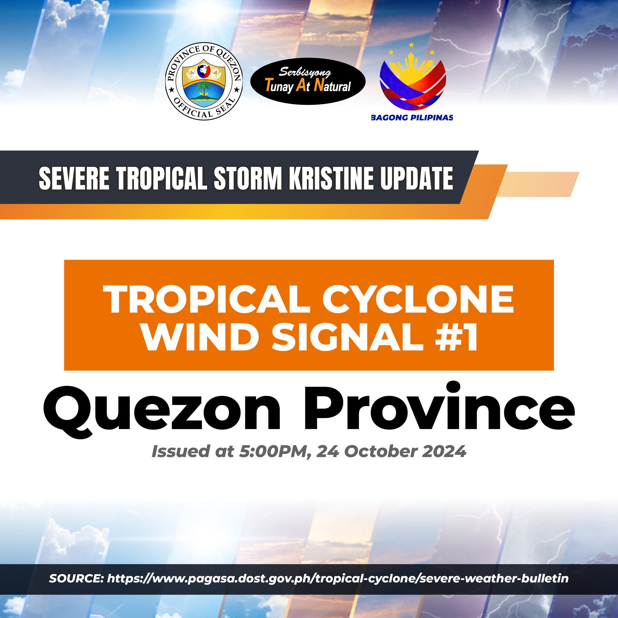
Quezon Province
Issued at 5:00PM, 24 October 2024
SOURCE: https://www.pagasa.dost.gov.ph/…/severe-weather-bulletin
Quezon PIO
![]() 𝐎𝐑𝐀𝐍𝐆𝐄 𝐖𝐀𝐑𝐍𝐈𝐍𝐆 𝐋𝐄𝐕𝐄𝐋: Quezon(Lucban, Tayabas, Lucena, Dolores, Tiaong, San Antonio, Sariaya, Candelaria)
𝐎𝐑𝐀𝐍𝐆𝐄 𝐖𝐀𝐑𝐍𝐈𝐍𝐆 𝐋𝐄𝐕𝐄𝐋: Quezon(Lucban, Tayabas, Lucena, Dolores, Tiaong, San Antonio, Sariaya, Candelaria)
BANTANG PANGANIB: 𝐌𝐚𝐲 𝐁𝐀𝐍𝐓𝐀 𝐧𝐠 𝐏𝐀𝐆𝐁𝐀𝐇𝐀 sa mga flood-prone na lugar
![]() 𝐘𝐄𝐋𝐋𝐎𝐖 𝐖𝐀𝐑𝐍𝐈𝐍𝐆 𝐋𝐄𝐕𝐄𝐋: Quezon(General Nakar, Infanta, Mauban, Pagbilao, Real, Sampaloc, Agdangan, Alabat, Atimonan, Buenavista, Burdeos, Calauag, Catanauan, General Luna, Guinayangan, Gumaca, Jomalig, Lopez, Macalelon, Mulanay, Padre Burgos, Panukulan, Patnanungan, Perez, Pitogo, Plaridel, Polillo, Quezon, San Andres, San Francisco, San Narciso, Tagkawayan, Unisan).
𝐘𝐄𝐋𝐋𝐎𝐖 𝐖𝐀𝐑𝐍𝐈𝐍𝐆 𝐋𝐄𝐕𝐄𝐋: Quezon(General Nakar, Infanta, Mauban, Pagbilao, Real, Sampaloc, Agdangan, Alabat, Atimonan, Buenavista, Burdeos, Calauag, Catanauan, General Luna, Guinayangan, Gumaca, Jomalig, Lopez, Macalelon, Mulanay, Padre Burgos, Panukulan, Patnanungan, Perez, Pitogo, Plaridel, Polillo, Quezon, San Andres, San Francisco, San Narciso, Tagkawayan, Unisan).
BANTANG PANGANIB: 𝐌𝐚𝐲 𝐩𝐨𝐬𝐢𝐛𝐢𝐥𝐢𝐝𝐚𝐝 𝐧𝐠 𝐏𝐀𝐆𝐁𝐀𝐇𝐀 sa mga flood-prone na lugar
Pinapayuhan ang publiko at ang mga kinauukulang mula sa Tanggapan ng Pamamahala at Pagpapababa ng Bantang Panganib at Sakuna na subaybayan ang lagay ng panahon at bantayan ang susunod na babala na ilalabas ngayong 8:00 PM.
Link:
Quezon PIO
Missing Person
-1 Fisherman Buenavista Quezon
Flooding Incident
-Catanuan
-Calauag
Road and Bridges
– Mauban
– San Narciso
– Tagkawayan
– Sariaya
– San Francisco
– Dolores
– Lopez
Power Interruption
– Mauban
– Dolores
– Sariaya
– San Antonio
– Catanauan
– Unisan
– Agdangan
– General Luna
– San Andres
– Guinayangan
– Alabat
Mobile Phone Interruption
– San Narciso
– Dolores
Ports
– Stranded Passengers-273
– Stranded Rolling Cargo-30
– Stranded Vessels/Motor Banca-32
Evacuees
-Affected Families-9,568
-Affected Individuals- 32,529
Damaged Houses
– Total Damaged-12
– Partially Damaged-91
Source: Quezon Provincial Disaster Risk Reduction and Management Office
Link:
Quezon PIO
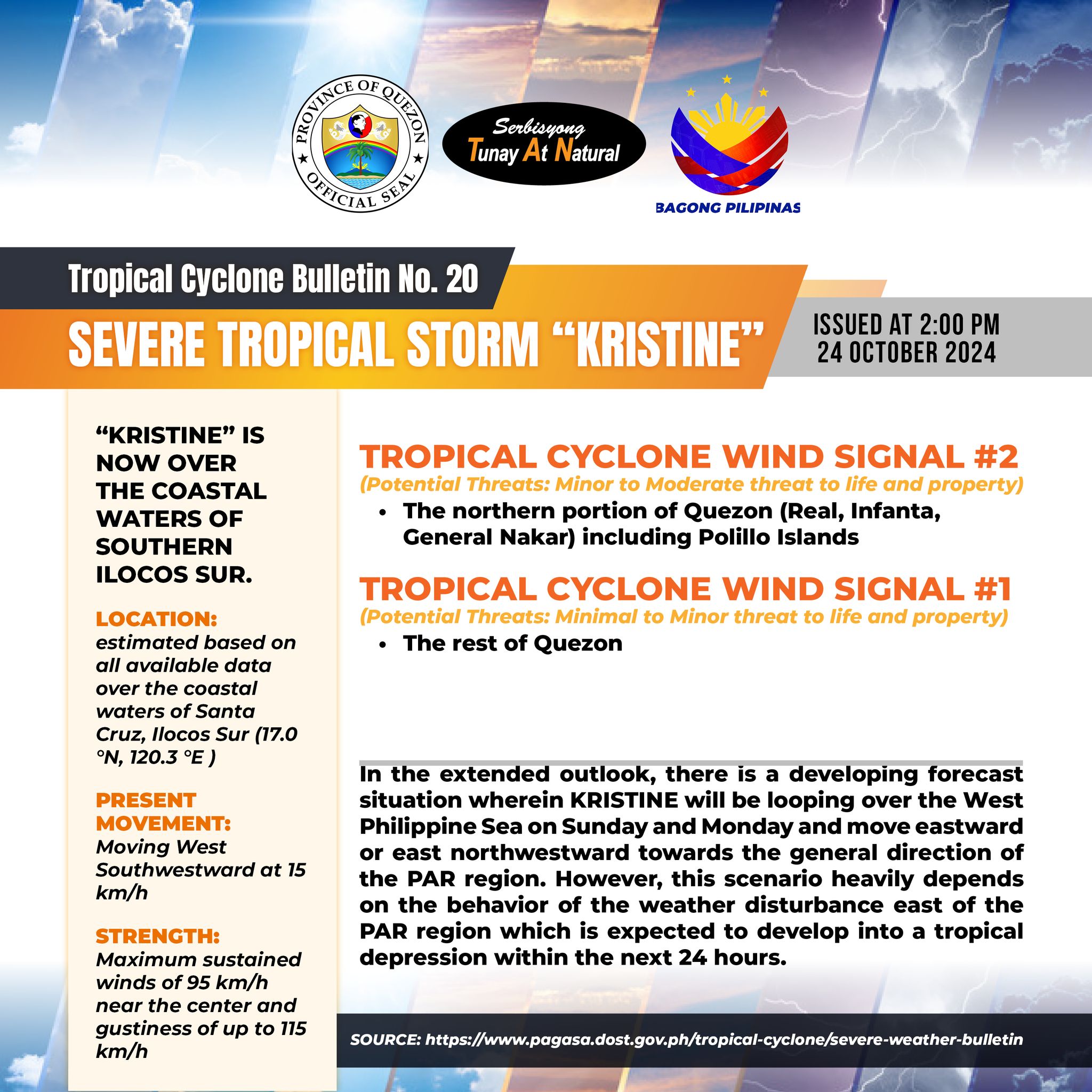
“KRISTINE” IS NOW OVER THE COASTAL WATERS OF SOUTHERN ILOCOS SUR.
LOCATION: in the vicinity of Aguinaldo, Ifugao (17.0 °N, 121.3 °E )
PRESENT MOVEMENT: Moving Westward at 15 km/h
STRENGTH: Maximum sustained winds of 95 km/h near the center and gustiness of up to 115 km/h
TROPICAL CYCLONE WIND SIGNAL #2
(Potential Threats: Minor to Moderate threat to life and property)
– the northern portion of Quezon (Real, Infanta, General Nakar) including Polillo Islands.
TROPICAL CYCLONE WIND SIGNAL #1
(Potential Threats: Minimal to Minor threat to life and property)
– The rest of Quezon
In the extended outlook, there is a developing forecast situation wherein KRISTINE will be looping over the West Philippine Sea on Sunday and Monday and move eastward or east northwestward towards the general direction of the PAR region. However, this scenario heavily depends on the behavior of the weather disturbance east of the PAR region which is expected to develop into a tropical depression within the next 24 hours.
Quezon PIO
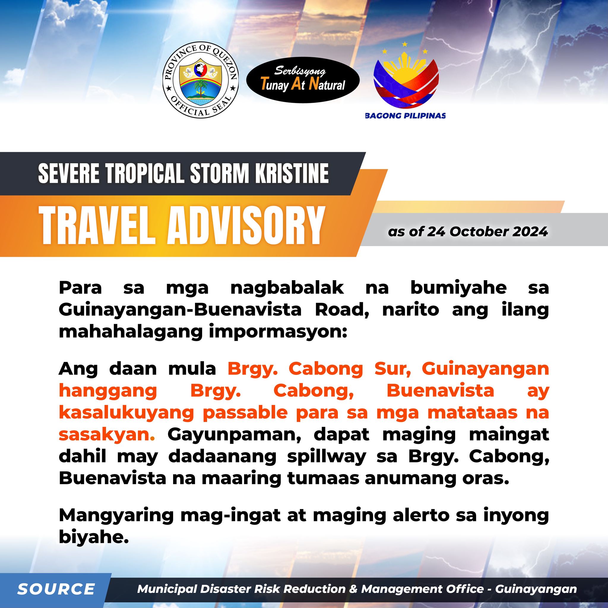
Para sa mga nagbabalak na bumiyahe sa Guinayangan-Buenavista Road, narito ang ilang mahahalagang impormasyon:
Ang daan mula Brgy. Cabong Sur, Guinayangan hanggang Brgy. Cabong, Buenavista ay kasalukuyang passable para sa mga matataas na sasakyan. Gayunpaman, dapat maging maingat dahil may dadaanang spillway sa Brgy. Cabong, Buenavista na maaring tumaas anumang oras.
Mangyaring mag-ingat at maging alerto sa inyong biyahe.
Source: MDRRMO Guinayangan
Quezon PIO
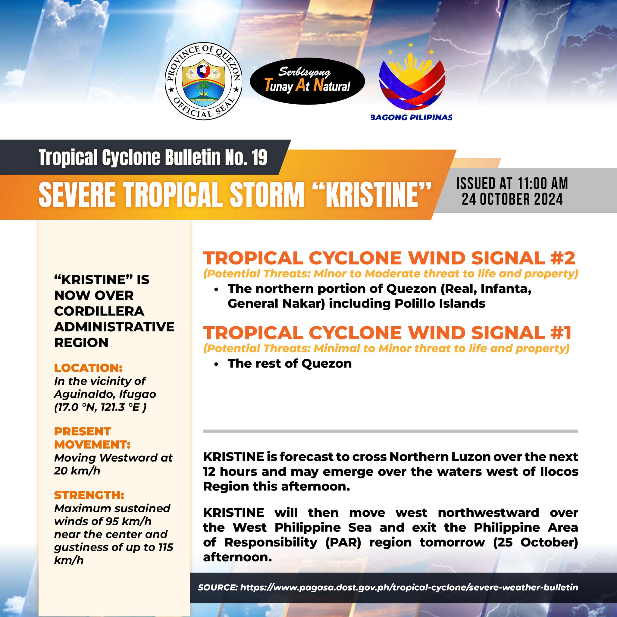
“KRISTINE” IS NOW OVER CORDILLERA ADMINISTRATIVE REGION.
LOCATION: in the vicinity of Aguinaldo, Ifugao (17.0 °N, 121.3 °E )
PRESENT MOVEMENT: Moving Westward at 20 km/h
STRENGTH: Maximum sustained winds of 95 km/h near the center and gustiness of up to 115 km/h
TROPICAL CYCLONE WIND SIGNAL #2
(Potential Threats: Minor to Moderate threat to life and property)
– the northern portion of Quezon (Real, Infanta, General Nakar) including Polillo Islands.
TROPICAL CYCLONE WIND SIGNAL #1
(Potential Threats: Minimal to Minor threat to life and property)
– The rest of Quezon
KRISTINE is forecast to cross Northern Luzon over the next 12 hours and may emerge over the waters west of Ilocos Region this afternoon.
KRISTINE will then move west northwestward over the West Philippine Sea and exit the Philippine Area of Responsibility (PAR) region tomorrow (25 October) afternoon.
Quezon PIO
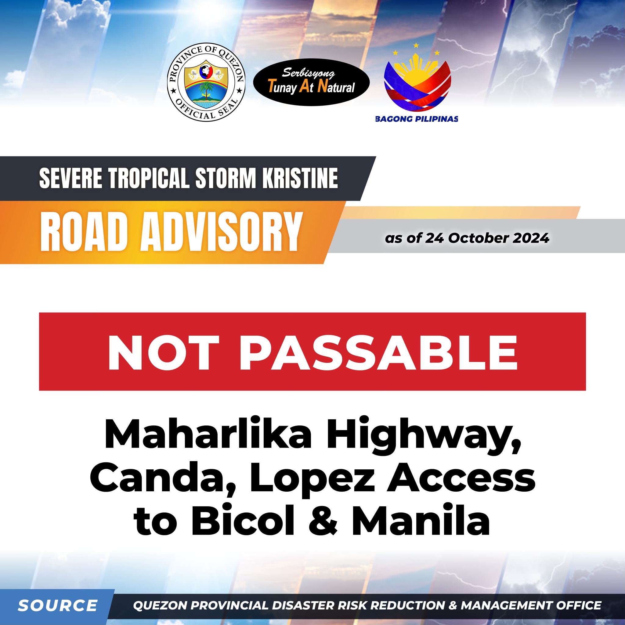
NOT PASSABLE: Maharlika Highway, Canda, Lopez Access to Bicol & Manila
Quezon PIO