NEWS AND UPDATE

Kalagayan ng Ilang Bayan sa Lalawigan ng Quezon Matapos ang Pagbuhos ng Malakas na Ulan Dulot ni Bagyong Kristine | October 23, 2024

Kalagayan ng Ilang Bayan sa Lalawigan ng Quezon Matapos ang Pagbuhos ng Malakas na Ulan Dulot ni Bagyong Kristine | October 23, 2024

alagayan ng ilang bayan sa lalawigan ng Quezon matapos ang pagbuhos ng malakas na ulan dulot ni Bagyong Kristine.

Sa tulong naman ng Satellite Offices at DSWD, agarang naipaabot ang mga tulong at relief packs para sa mga naapektuhan nating mga kalalawigan.

Link:

https://www.facebook.com/QuezonGovPh/posts/pfbid0Eipy8PPX2tHtcLrEqjHRsmLQagSRsPBz9asbJhq1aD4i9SAZTTW9uoWubrgm6c4hl?rdid=E2H2lXJJpbjoDmhY


Quezon PIO

Tropical Cyclone Wind Signal No. 2

Tropical Cyclone Wind Signal No. 2

As of 11 AM, Oct. 23, nakataas na ang Tropical Cyclone Wind Signal No. 2 sa buong probinsya ng Quezon kasama ang Polillo Islands.


Quezon PIO

Tropical Cyclone Bulletin No. 11 TROPICAL STORM “KRISTINE” Issued at 11:00 am | 23 October 2024

Tropical Cyclone Bulletin No. 11 TROPICAL STORM “KRISTINE” Issued at 11:00 am | 23 October 2024

“KRISTINE” SLIGHTLY ACCELERATES WHILE MAINTAINING ITS STRENGTH OVER THE SEA EAST OF AURORA

LOCATION: 200 km East of Casiguran, Aurora or 255 km East of Baler, Aurora

PRESENT MOVEMENT: North northwestward at 30 kph

STRENGTH: Maximum sustained winds of 85 km/h near the center and gustiness of up to 105 km/h

TROPICAL CYCLONE WIND SIGNAL #2

(Potential Threats: Minor to Moderate threat to life and property)

– Quezon including Polillo Islands

KRISTINE is forecast to move generally northwestward for the next 12 hours before turning generally westward for the rest of the forecast period. It is forecast to make landfall over Isabela tonight. It will then cross the mountainous terrain of Northern Luzon and emerge over the waters west of Ilocos Region tomorrow morning.

KRISTINE may exit the Philippine Area of Responsibility (PAR) region on Friday (25 October).

KRISTINE is forecast to intensify into a severe tropical storm before making landfall. Slight weakening will occur while crossing Northern Luzon. Re-intensification may occur over the West Philippine Sea.


Quezon PIO

Tuloy-tuloy ang Pagtutok ng Pamahalaang Panlalawigan sa Pangunguna ni Governor Doktora Helen Tan sa BAGYONG KRISTINE | October 23, 2024

Tuloy-tuloy ang Pagtutok ng Pamahalaang Panlalawigan sa Pangunguna ni Governor Doktora Helen Tan sa BAGYONG KRISTINE | October 23, 2024

Tuloy-tuloy ang pagtutok ng Pamahalaang Panlalawigan sa pangunguna ni Governor Doktora Helen Tan sa BAGYONG KRISTINE ngayong araw, Oktubre 23.

Kasalukuyang nasa Quezon Preparedness Operation Center (QPOC) ang Gobernadora kasama sina Provincial Administrator Manuel Butardo, Provincial Information Officer Jun Lubid, Provincial Disaster Risk Reduction and Management Officer Dr. Melchor Avenilla Jr., Provincial Social Welfare and Development Officer Sonia Leyson, at Provincial Budget Officer Diego Salas.

Nakahanda namang rumesponde ang mga katuwang na mga ahensya ng gobyerno gaya ng PNP, PCG, AFP at BFP para sa search and rescue operations sa mga apektado ng nasabing bagyo.


Quezon PIO

𝗦𝗧𝗢𝗥𝗠 𝗦𝗨𝗥𝗚𝗘 𝗪𝗔𝗥𝗡𝗜𝗡𝗚 #𝟬𝟓 𝐓𝐫𝐨𝐩𝐢𝐜𝐚𝐥 𝐒𝐭𝐨𝐫𝐦 𝐊𝐫𝐢𝐬𝐭𝐢𝐧𝐞 𝐈𝐬𝐬𝐮𝐞𝐝 𝐚𝐭 𝟖:𝟎𝟎𝐀𝐌, 𝐖𝐞𝐧𝐞𝐬𝐝𝐚𝐲 | 𝟐𝟑 𝐎𝐜𝐭𝐨𝐛𝐞𝐫 𝟐𝟎𝟐𝟒

𝗦𝗧𝗢𝗥𝗠 𝗦𝗨𝗥𝗚𝗘 𝗪𝗔𝗥𝗡𝗜𝗡𝗚 #𝟬𝟓 𝐓𝐫𝐨𝐩𝐢𝐜𝐚𝐥 𝐒𝐭𝐨𝐫𝐦 𝐊𝐫𝐢𝐬𝐭𝐢𝐧𝐞 𝐈𝐬𝐬𝐮𝐞𝐝 𝐚𝐭 𝟖:𝟎𝟎𝐀𝐌, 𝐖𝐞𝐧𝐞𝐬𝐝𝐚𝐲 | 𝟐𝟑 𝐎𝐜𝐭𝐨𝐛𝐞𝐫 𝟐𝟎𝟐𝟒

KATAMTAMAN hanggang MATAAS na panganib ng storm surge ang maaaring mangyari sa susunod na 48 oras. Gayunpaman, ang mga residente sa kahabaan ng baybayin ay pinapayuhan na maging maingat dahil sa mataas na alon sa ilang munisipalidad sa lalawigan ng 𝐐𝐔𝐄𝐙𝐎𝐍 (𝐁𝐔𝐑𝐃𝐄𝐎𝐒, 𝐆𝐄𝐍𝐄𝐑𝐀𝐋 𝐍𝐀𝐊𝐀𝐑, 𝐏𝐀𝐍𝐔𝐊𝐔𝐋𝐀𝐍)

𝐑𝐞𝐜𝐨𝐦𝐦𝐞𝐧𝐝𝐞𝐝 𝐀𝐜𝐭𝐢𝐨𝐧:

Ang mga residente na nakatira sa mabababang coastal communities ay pinapayuhan na:

• Iwasan ang paglapit sa baybayin o dalampasigan;

• I-cancel ang lahat ng aktibidad sa dagat;

• Maging mapagmatyag at sundin ang pinakabagong update mula sa PAGASA.

Ang publiko at ang mga tanggapan ng disaster risk reduction at management ay pinapayuhan na gumawa ng angkop na hakbang at mga precautionary measures, at maghintay para sa susunod na impormasyon ukol sa storm surge na ilalabas ng 2:00 PM ngayon.


Quezon PIO

SEA TRAVEL ADVISORY

SEA TRAVEL ADVISORY

Kanselado ang lahat ng byaheng pandagat sa mga pantalan sa rehiyon ng Calabarzon kasunod ng pagtataas ng Tropical Cyclone Wind Signal No.1 dahil sa Bagyong #KristinePH.

Pinapayuhan ang mga maglalakbay na pansamantalang itigil ang pagbyahe upang maiwasan ang pagdami ng stranded na mga pasahero sa mga pantalan. | via RDRRMC CALABARZON/PCG


Quezon PIO

SITUATIONAL REPORT | BAGYONG KRISTINE October 23, 2024 (Wednesday) as of 5:00 AM

SITUATIONAL REPORT | BAGYONG KRISTINE October 23, 2024 (Wednesday) as of 5:00 AM

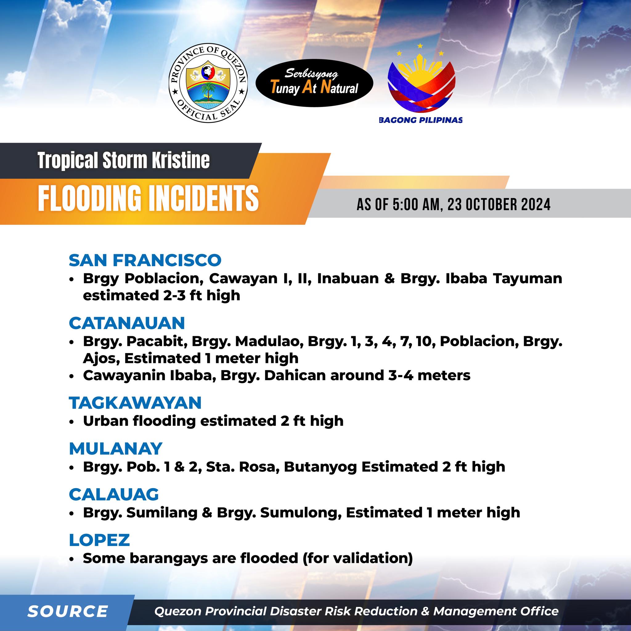
LGUs with Reported Flooding:

• CALAUAG – Brgy. Sumilang & Brgy Sumulong, ESTIMATED OF 1 METER HIGH

• LOPEZ – Some Brgy. are flooded (For Validation)

• SAN FRANCISCO – Brgy Poblacion, Cawayan I, II, Inabuan & Brgy. Ibaba Tayuman, ESTIMATED 2-3FT HIGH

• CATANAUAN – Brgy. Pacabit, Brgy. Madulao, Brgy. 1, 3, 4, 7, 10 Poblacion, Brgy. Ajos, ESTIMATED 1 METER HIGH. Cawayanin Ibaba, Brgy. Dahican, AROUND 3-4 METERS

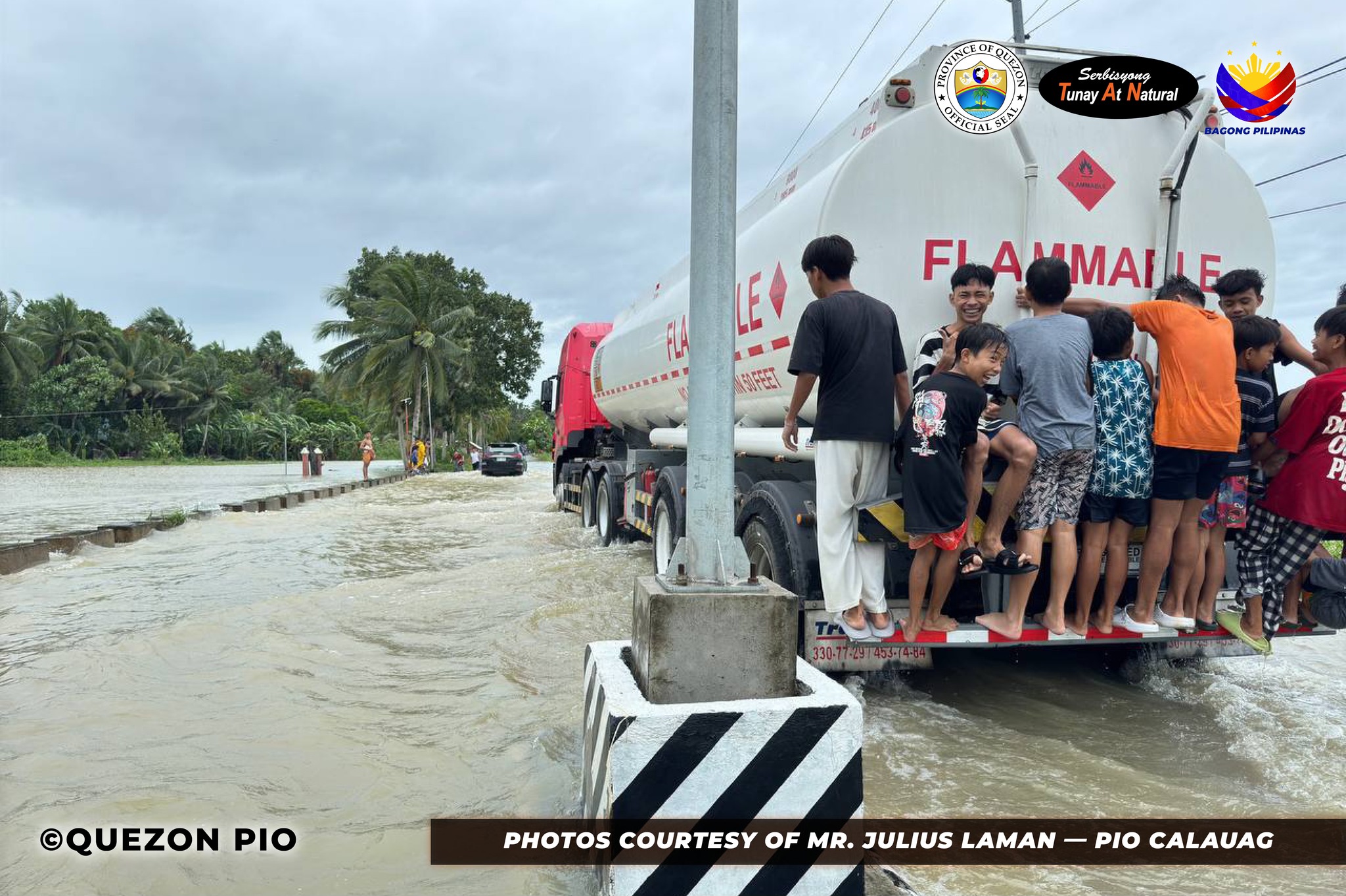
• TAGKAWAYAN – Urban Flooding ESTIMATED 2FT HIGH

• MULANAY – Brgy. Pob 1 & 2, Sta. Rosa, Buntayog, ESTIMATED 2FT HIGH
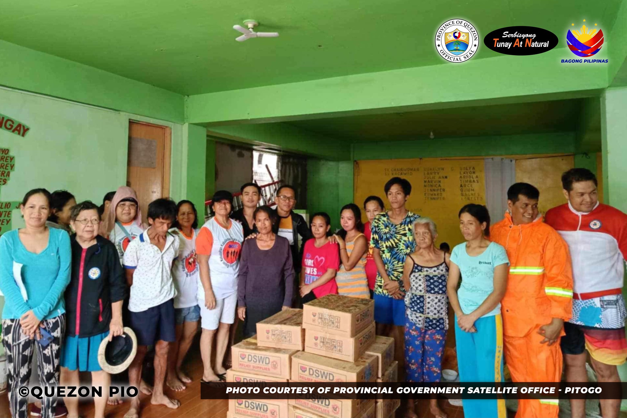
Reported Evacuees:

• FIRST DISTRICT – 954 Affected Families; 3,250 Affected Individuals

• SECOND DISTRICT – 178 Affected Families; 550 Affected Individuals

• THIRD DISTRICT – 651 Affected Families; 2,129 Affected Individuals

• FOURTH DISTRICT – 392 Affected Families; 1,339 Affected Individuals

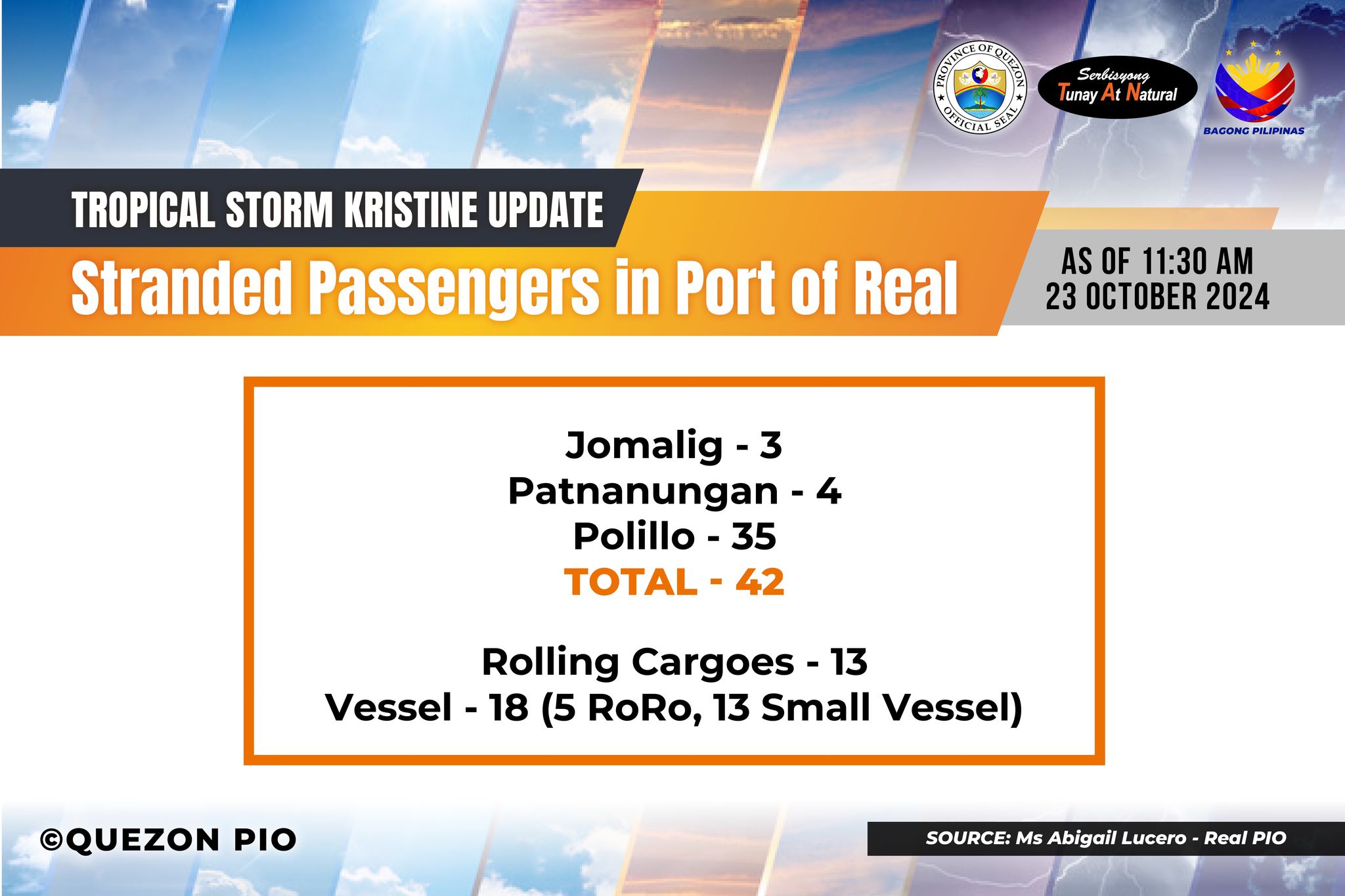
Reported Stranded at Ports:

477 Stranded Passengers

46 Stranded Rolling Cargo

10 Stranded Vessels

Link: https://www.facebook.com/QuezonGovPh/posts/pfbid0u7Wh8agPZYZ7FBZStjeRAPZKWDjQcsqBkeBi5WU3TVGB8ghxKT4DPf5iYhqfVA1vl?rdid=QH34AB3vnss7HWqJ


Quezon PIO