
Lingap sa Mamamayan, Libreng Gamutan – Gumaca, Quezon | November 09, 2024
Livestream part 1: https://www.facebook.com/share/v/mHYxGskk6wAXKFvA/
Livestream part 2: https://www.facebook.com/QuezonGovPh/videos/907297077652954/
Quezon PIO


Livestream part 1: https://www.facebook.com/share/v/mHYxGskk6wAXKFvA/
Livestream part 2: https://www.facebook.com/QuezonGovPh/videos/907297077652954/
Quezon PIO
Validity: Valid within the forecast period, unless superseded by succeeding forecast.
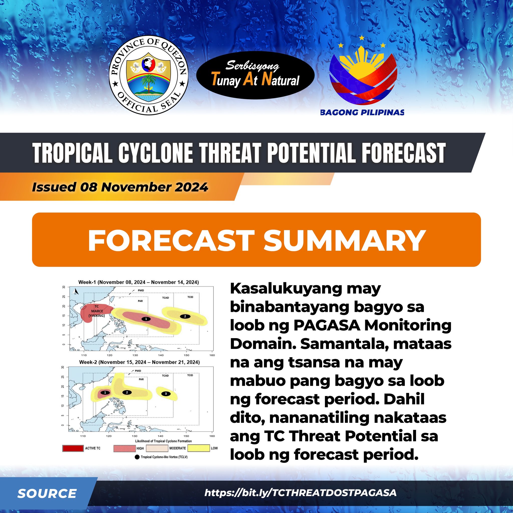
Forecast Summary: 𝗞𝗔𝗦𝗔𝗟𝗨𝗞𝗨𝗬𝗔𝗡𝗚 𝗠𝗔𝗬 𝗕𝗜𝗡𝗔𝗕𝗔𝗡𝗧𝗔𝗬𝗔𝗡𝗚 𝗕𝗔𝗚𝗬𝗢 𝗦𝗔 𝗟𝗢𝗢𝗕 𝗡𝗚 𝗣𝗔𝗚𝗔𝗦𝗔 𝗠𝗢𝗡𝗜𝗧𝗢𝗥𝗜𝗡𝗚 𝗗𝗢𝗠𝗔𝗜𝗡. 𝗦𝗔𝗠𝗔𝗡𝗧𝗔𝗟𝗔, 𝗠𝗔𝗧𝗔𝗔𝗦 𝗡𝗔 𝗔𝗡𝗚 𝗧𝗬𝗔𝗡𝗦𝗔 𝗡𝗔 𝗠𝗔𝗬 𝗠𝗔𝗕𝗨𝗢 𝗣𝗔𝗡𝗚 𝗕𝗔𝗚𝗬𝗢 𝗦𝗔 𝗟𝗢𝗢𝗕 𝗡𝗚 𝗙𝗢𝗥𝗘𝗖𝗔𝗦𝗧 𝗣𝗘𝗥𝗜𝗢𝗗. 𝗗𝗔𝗛𝗜𝗟 𝗗𝗜𝗧𝗢, 𝗡𝗔𝗡𝗔𝗡𝗔𝗧𝗜𝗟𝗜𝗡𝗚 𝗡𝗔𝗞𝗔𝗧𝗔𝗔𝗦 𝗔𝗡𝗚 𝗧𝗖 𝗧𝗛𝗥𝗘𝗔𝗧 𝗣𝗢𝗧𝗘𝗡𝗧𝗜𝗔𝗟 𝗦𝗔 𝗟𝗢𝗢𝗕 𝗡𝗚 𝗙𝗢𝗥𝗘𝗖𝗔𝗦𝗧 𝗣𝗘𝗥𝗜𝗢𝗗.
Para sa karagdagang impormasyon, bisitahin ang link na ito: https://bit.ly/TCTHREATDOSTPAGASA
Quezon PIO

DISCLAIMER: I hereby declare that I do not own the rights to this music/song. All rights belong to the owner. No Copyright Infringement Intended.
Livestream Part 1: https://www.facebook.com/QuezonGovPh/videos/3114045098737964/
Quezon PIO

DISCLAIMER: I hereby declare that I do not own the rights to this music/song. All rights belong to the owner. No Copyright Infringement Intended.
Livestream: https://www.facebook.com/QuezonGovPh/videos/1334481394183509/
Quezon PIO
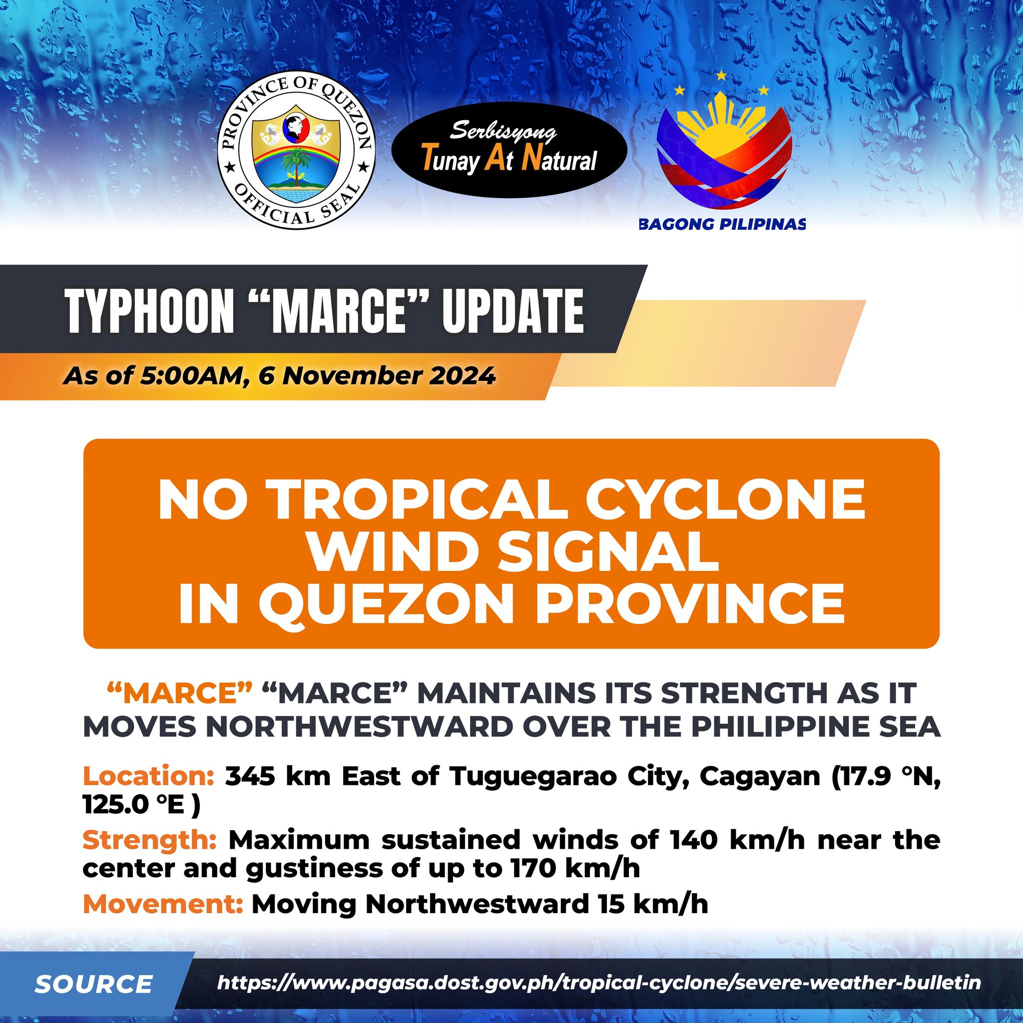
“MARCE” “MARCE” MAINTAINS ITS STRENGTH AS IT MOVES NORTHWESTWARD OVER THE PHILIPPINE SEA
Location: 345 km East of Tuguegarao City, Cagayan (17.9 °N, 125.0 °E )
Strength: Maximum sustained winds of 140 km/h near the center and gustiness of up to 170 km/h
Movement: Moving Northwestward 15 km/h
NO TROPICAL CYCLONE WIND SIGNAL (TWCS) IN EFFECT OVER QUEZON PROVINCE
MARCE is forecast to move generally west northwestward today (6 November) as it decelerates over the Philippine Sea east of Northern Luzon. It is then forecast to turn westward tomorrow (7 November) as it approaches Babuyan Islands and northern Cagayan. On the forecast track, MARCE will make landfall or pass close to Babuyan Islands or the northern portion of mainland Cagayan from Thursday afternoon to Friday (8 November) early morning. MARCE may exit the Philippine Area of Responsibility (PAR) region on Friday evening.
MARCE is expected to continue intensifying and may reach its peak intensity today before it makes landfall or pass close to Babuyan Islands or Cagayan tomorrow.
Quezon PIO
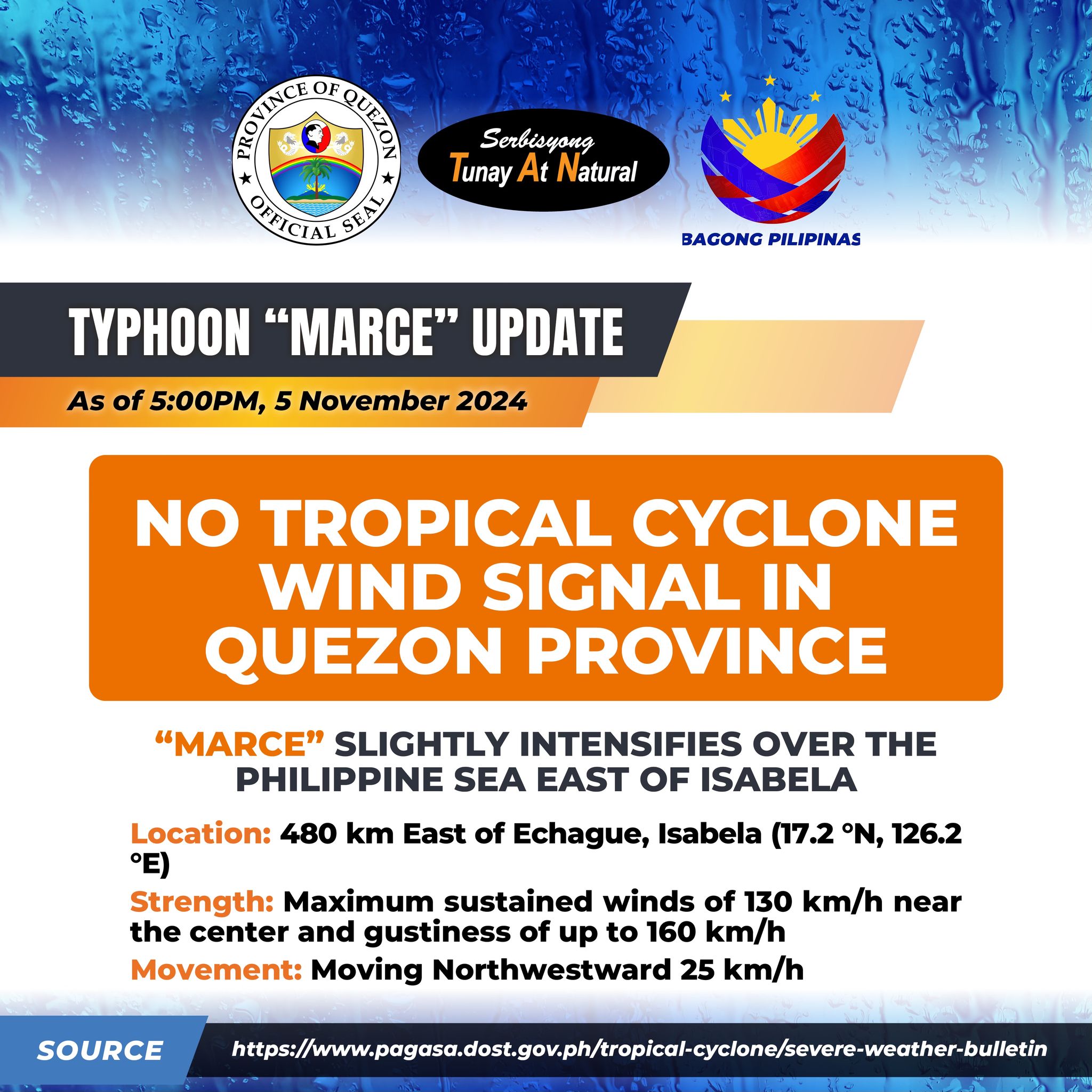
“MARCE” SLIGHTLY INTENSIFIES OVER THE PHILIPPINE SEA EAST OF ISABELA
Location: 480 km East of Echague, Isabela (17.2 °N, 126.2 °E)
Strength: Maximum sustained winds of 130 km/h near the center and gustiness of up to 160 km/h
Movement: Moving Northwestward 25 km/h
NO TROPICAL CYCLONE WIND SIGNAL (TWCS) IN EFFECT OVER QUEZON PROVINCE
MARCE is forecast to move generally west northwestward today until tomorrow (6 November) before decelerating and turning westward over the Philippine Sea east of Extreme Northern Luzon. On the forecast track, MARCE will make landfall or pass close to Babuyan Islands or the northern portion of mainland Cagayan on Thursday afternoon or evening (7 November). MARCE may exit the Philippine Area of Responsibility (PAR) region on Friday afternoon or evening.
MARCE is expected to continue intensifying and may reach its peak intensity before making landfall over Babuyan Islands or Cagayan.
Quezon PIO
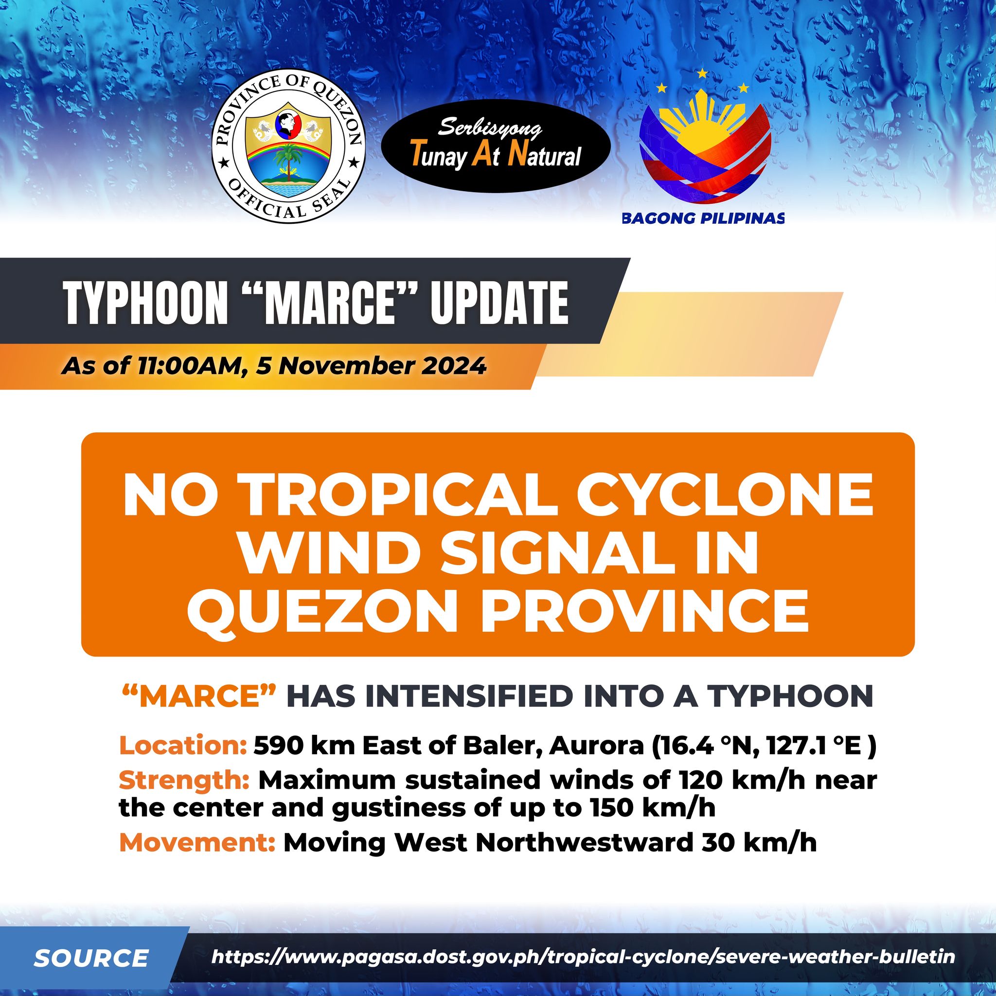
Location: 590 km East of Baler, Aurora (16.4 °N, 127.1 °E )
Movement: Moving West Northwestward 30 km/h
Strength: Maximum sustained winds of 120 km/h near the center and gustiness of up to 150 km/h
NO TROPICAL CYCLONE WIND SIGNAL (TWCS) IN EFFECT OVER QUEZON PROVINCE
MARCE is forecast to move generally west northwestward today until tomorrow (6 November) morning before decelerating and turning westward over the Philippine Sea east of Extreme Northern Luzon. On the forecast track, MARCE may make landfall in the vicinity of Babuyan Islands or over the northern portion of mainland Cagayan on Thursday evening (7 November) or Friday (8 November) early morning.
Due to uncertainty in the strength of the high pressure area north of MARCE, the forecast track may still change and bring the landfall point to mainland Cagayan-Isabela area. MARCE may exit the Philippine Area of Responsibility (PAR) region on Friday evening or Saturday (9 November) early morning.
Quezon PIO
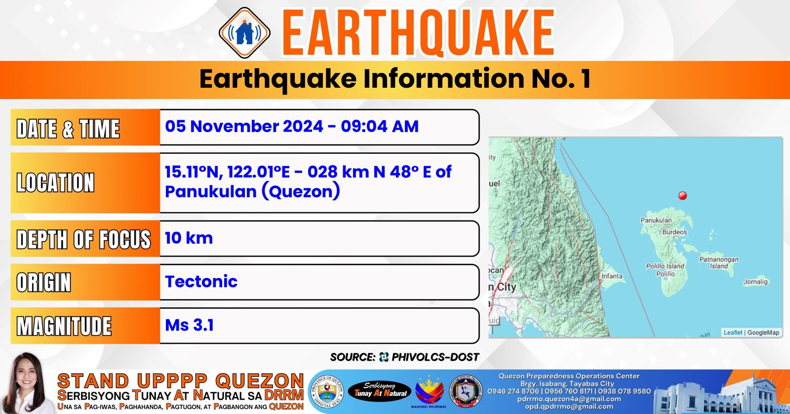
Magnitude = 3.1
Depth = 010 km
Location = 15.11°N, 122.01°E – 028 km N 48° E of Panukulan (Quezon)
Quezon PIO

Katamtaman hanggang sa malakas na pag-ulan na may kasamang pagkulog-pagkidlat at malakas na bugso ng hangin ay nararanasan sa 𝐐𝐮𝐞𝐳𝐨𝐧 (𝐑𝐞𝐚𝐥, 𝐌𝐚𝐮𝐛𝐚𝐧, 𝐏𝐚𝐠𝐛𝐢𝐥𝐚𝐨, 𝐋𝐮𝐜𝐞𝐧𝐚) na maaring magtagal hanggang sa susunod na dalawang oras at maaring makaapekto sa mga karatig na lugar.
Pinapayuhan ang lahat na mag-ingat at maging alerto sa posibleng panganib ng pagbaha at pagguho ng lupa.
Panatilihin ang pagsubaybay sa mga susunod na updates.
Quezon PIO
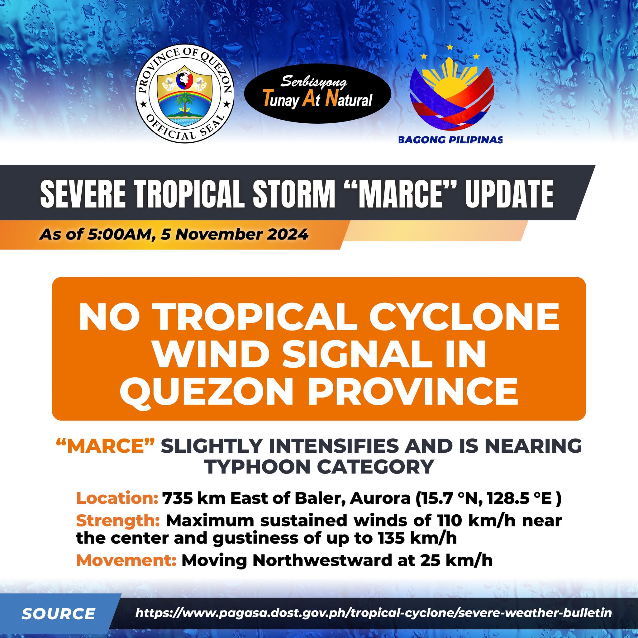
“MARCE” SLIGHTLY INTENSIFIES AND IS NEARING TYPHOON CATEGORY.
Location: 735 km East of Baler, Aurora (15.7 °N, 128.5 °E )
Movement: Moving Northwestward at 25 km/h
Strength: Maximum sustained winds of 110 km/h near the center and gustiness of up to 135 km/h
NO TROPICAL CYCLONE WIND SIGNAL IN QUEZON PROVINCE
MARCE is forecast to move generally west northwestward today until tomorrow (6 November) morning before decelerating and turning westward over the Philippine Sea east of Extreme Northern Luzon. On the forecast track, MARCE may make landfall in the vicinity of Babuyan Islands or over the northern portion of mainland Cagayan on Thursday evening (7 November) or Friday (8 November) early morning. Due to uncertainty in the strength of the high pressure area north of MARCE, the forecast track may still change and bring the landfall point to mainland Cagayan-Isabela area. MARCE may exit the Philippine Area of Responsibility (PAR) region on Friday evening or Saturday (9 November) early morning.
Quezon PIO