
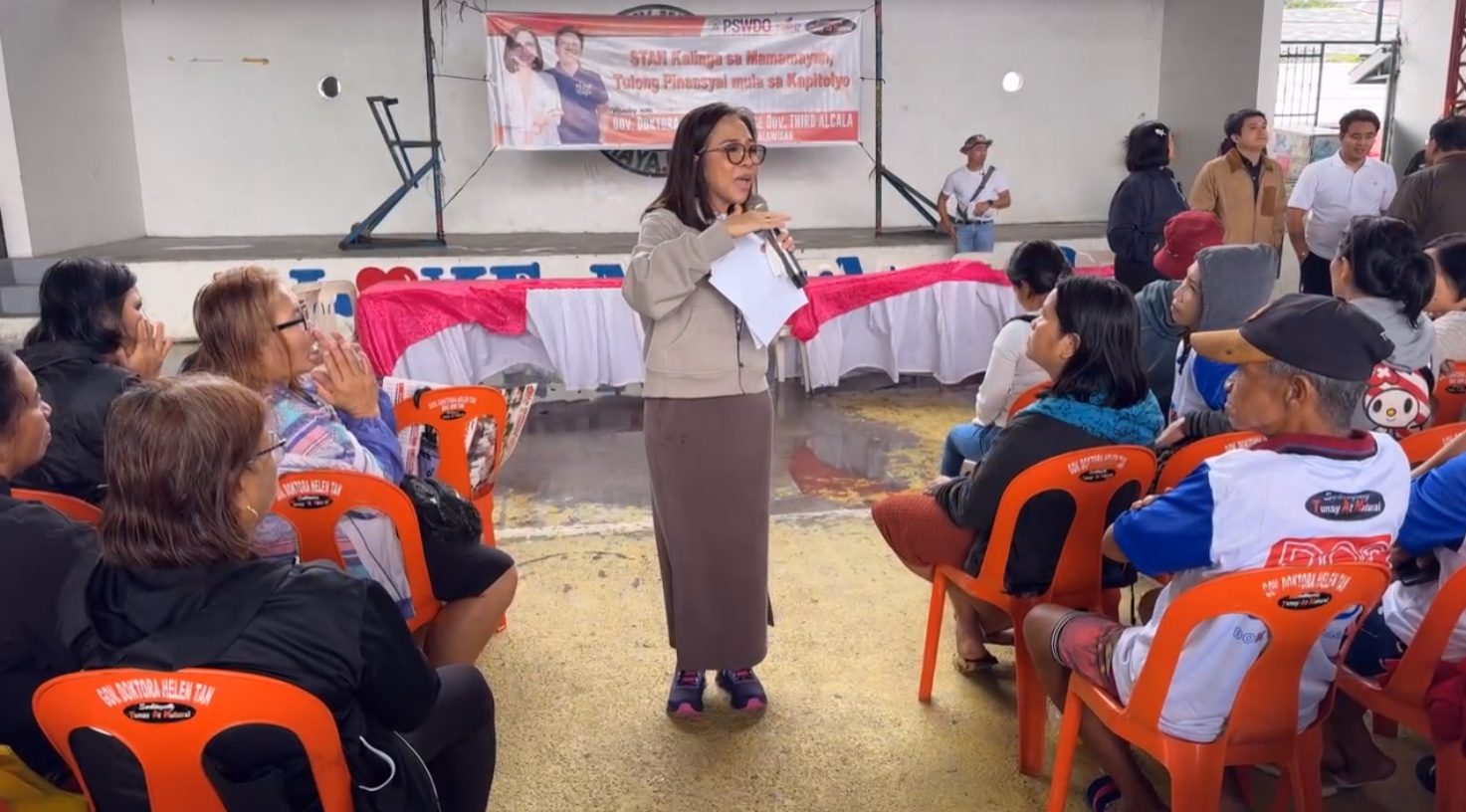
STAN Kalinga sa Mamamayan, Tulong Pinansyal mula sa Kapitolyo | December 17, 2024
Livestream: https://www.facebook.com/QuezonGovPh/videos/630940619260144/
Quezon PIO


Livestream: https://www.facebook.com/QuezonGovPh/videos/630940619260144/
Quezon PIO
Livestream: https://www.facebook.com/QuezonGovPh/videos/919911813184889/
Quezon PIO

Livestream part 1: https://www.facebook.com/QuezonGovPh/videos/3508664306105961/
Livestream part 2: https://www.facebook.com/watch/live/?ref=watch_permalink&v=497236869438862
Quezon PIO

I hereby declare that I do not own the rights to this music/song. All rights belong to the owner. No Copyright Infringement Intended.
Livestream: https://www.facebook.com/QuezonGovPh/videos/927945902282268/
Quezon PIO
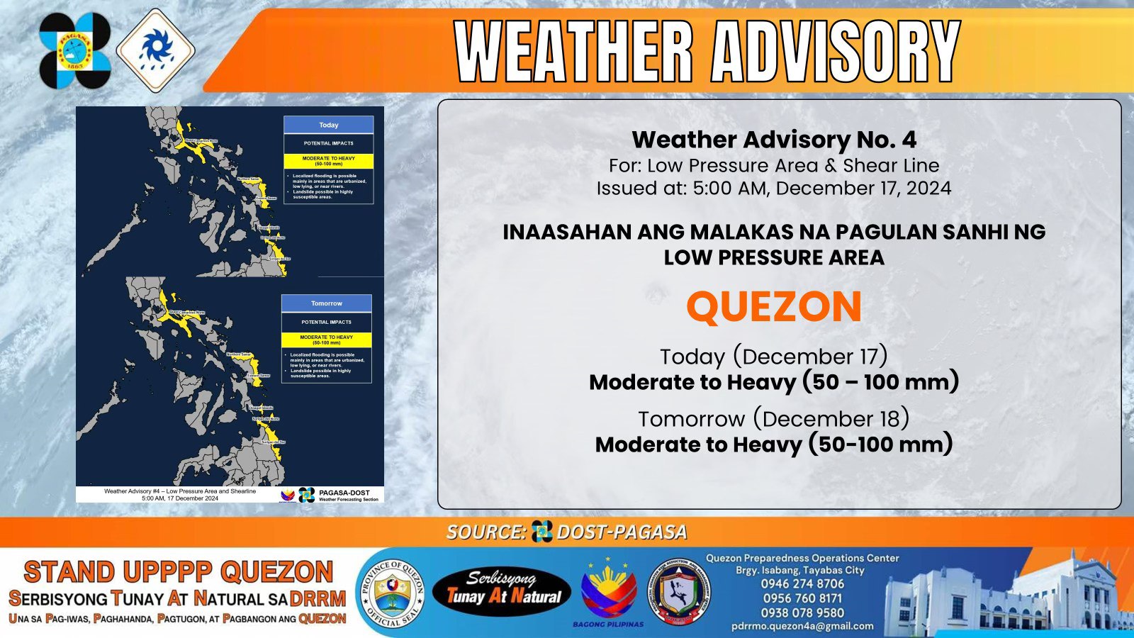
INAASAHAN ANG MALAKAS NA PAG-ULAN SANHI NG
LOW PRESSURE AREA
𝐐𝐔𝐄𝐙𝐎𝐍 𝐅𝐨𝐫𝐞𝐜𝐚𝐬𝐭 𝐑𝐚𝐢𝐧𝐟𝐚𝐥𝐥
Today (December 17): 𝐌𝐨𝐝𝐞𝐫𝐚𝐭𝐞 𝐭𝐨 𝐇𝐞𝐚𝐯𝐲 (𝟓𝟎 – 𝟏𝟎𝟎 𝐦𝐦)
Tomorrow (December 18): 𝐌𝐨𝐝𝐞𝐫𝐚𝐭𝐞 𝐭𝐨 𝐇𝐞𝐚𝐯𝐲 (𝟓𝟎 – 𝟏𝟎𝟎 𝐦𝐦)
𝐏𝐨𝐭𝐞𝐧𝐭𝐢𝐚𝐥 𝐈𝐦𝐩𝐚𝐜𝐭𝐬
𝐋𝐨𝐜𝐚𝐥𝐢𝐳𝐞𝐝 𝐅𝐥𝐨𝐨𝐝𝐢𝐧𝐠: Maaaring mangyari, partikular na sa mga lugar na urbanisado, mababa ang lokasyon, o malapit sa mga ilog.
𝐋𝐚𝐧𝐝𝐬𝐥𝐢𝐝𝐞: Posibleng maganap sa mga lugar na lubhang bulnerable sa pagguho ng lupa, lalo na sa matarik at bundok na rehiyon.
Hinihikayat ang publiko at ang mga tanggapan ng disaster risk reduction and management na magpatupad ng mga kinakailangang hakbang upang maprotektahan ang buhay at ari-arian. Ang mga PAGASA Regional Services Divisions ay maaaring maglabas ng Heavy Rainfall Warnings, Rainfall/Thunderstorm Advisories, at iba pang impormasyon ukol sa malalakas na pag-ulan ayon sa kanilang nasasakupan.
Kung walang makabuluhang pagbabago, ang susunod na Weather Advisory ay ilalabas mamayang ala 11:00 ng umaga.
Quezon PIO

I hereby declare that I do not own the rights to this music/song. All rights belong to the owner. No Copyright Infringement Intended.
Livestream part 1: https://www.facebook.com/QuezonGovPh/videos/2284215218625370/
Livestream part 2: https://www.facebook.com/watch/live/?ref=watch_permalink&v=617448577459230&rdid=Xv2Ii0FaJHBcYkuY
Quezon PIO
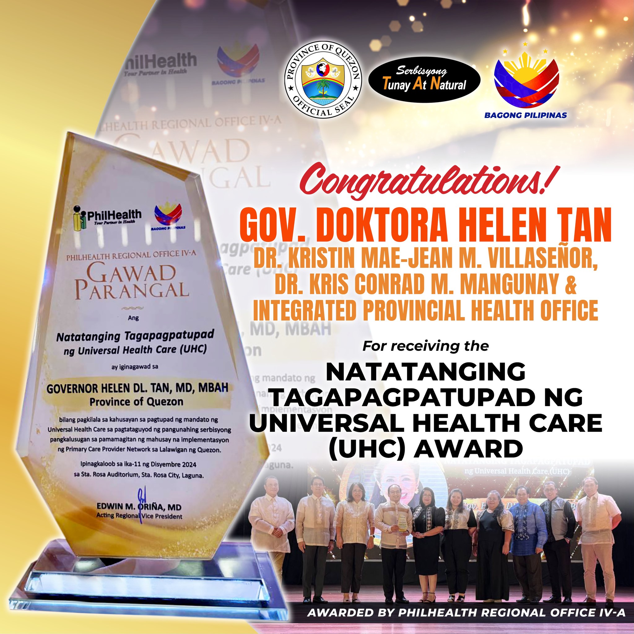
CONGRATULATIONS GOVERNOR DOKTORA HELEN TAN!
Pinarangalan si Governor Doktora Helen Tan sa Gawad Parangal ng Philhealth Regional Office IV-A bilang Natatanging Tagapagpatupad ng Universal Health Care (UHC), nitong araw ng Miyerkules, Disyembre 11, sa Sta. Rosa Auditorium, Sta. Rosa City, Laguna.
Ang nasabing parangal ay bilang pagkilala sa kahusayan sa pagtupad ng mandato ng UHC sa pagtataguyod ng pangunahing serbisyong pangkalusugan sa pamamagitan ng mahusay na implementasyon sa Primary Care Provider Network sa Lalawigan ng Quezon.
Kasama sa pinarangalan sina Integrated Provincial Health Officer Dr. Kristin Mae-Jean M. Villaseñor, Acting Provincial Health Officer II Dr. Kris Conrad M. Mangunay at departamento ng Integrated Provincial Health Office.
Samantala, taos-pusong nagpapasalamat si Governor Tan sa parangal na natanggap, at patuloy na maglilingkod para sa kagalingan at kalusugan ng mga mamamayang Quezonian.
Quezon PIO
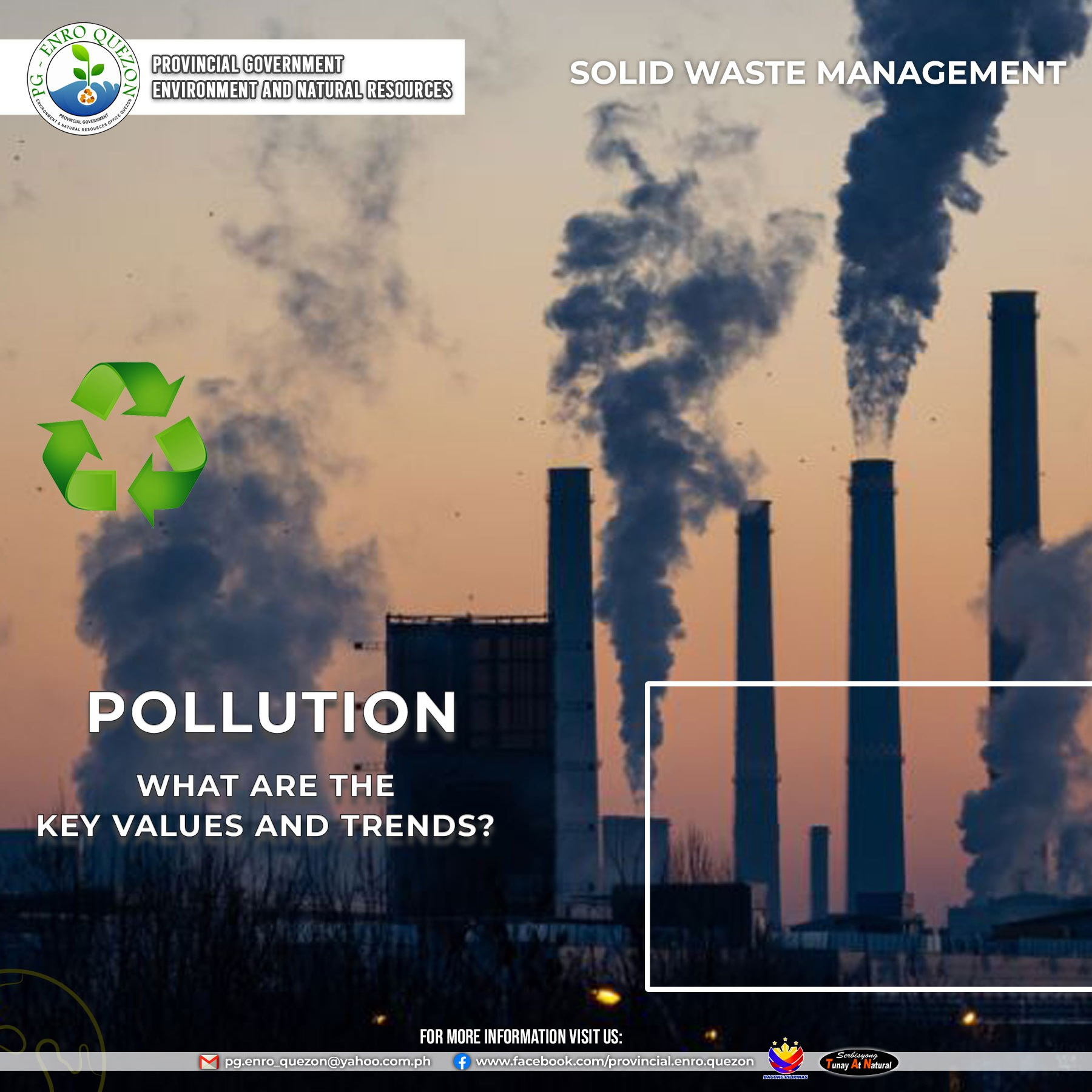
![]() SWM Air & Water || POLLUTION: What are the key values and trends?
SWM Air & Water || POLLUTION: What are the key values and trends?
The Philippines faces significant environmental challenges due to rapid development, industrialization, and urbanization. These include air, water, and waste pollution. Air quality in the country is deemed moderately unsafe, with pollution from fossil fuels causing around 27,000 premature deaths annually and economic losses of 1.9% of GDP. Water pollution is a growing concern, with the Pasig River, once vital, now classified as biologically dead, and Laguna de Bay suffering from pollution and harmful algal blooms that affect fishing and agriculture.
Solid waste management is a major issue, with increasing waste generation, especially in urban areas like Metro Manila. A significant portion of waste is uncollected, contributing to pollution in water bodies and flooding. Open dumping is still common due to the limited availability of controlled dumpsites. Additionally, the Philippines is one of the top contributors to plastic waste in the ocean, with 0.75 million metric tons entering the ocean annually, exacerbated by the COVID-19 pandemic’s increase in single-use plastic consumption. Plastic pollution is now considered a national crisis.
Read full study here:
https://dicf.unepgrid.ch/philippines/pollution
References:
https://dicf.unepgrid.ch/philippines/pollution
Photo Credits:
Huge pipes shoot steams at the sky (Ella Ivanescu via Unsplash)
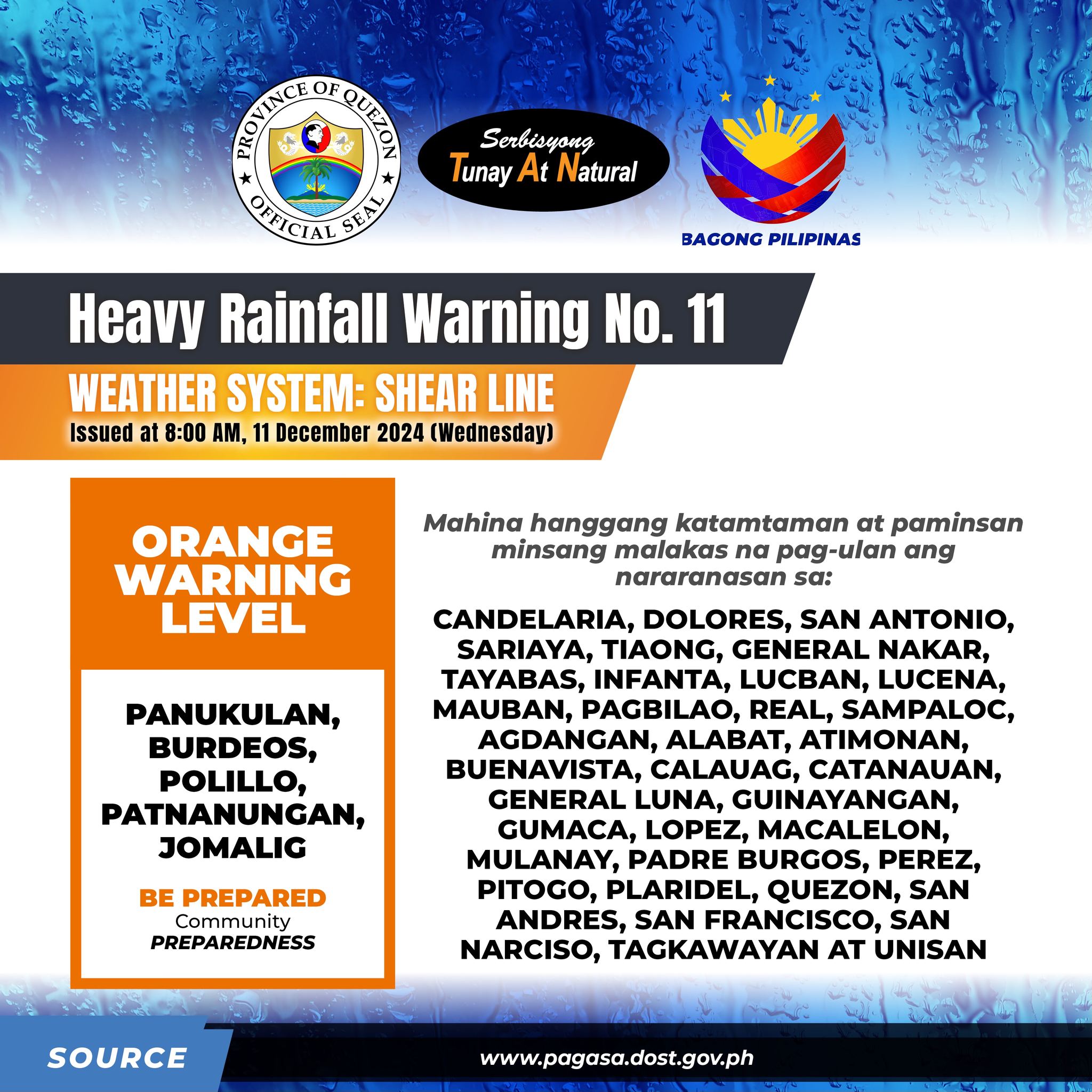
![]() 𝐎𝐑𝐀𝐍𝐆𝐄 𝐖𝐀𝐑𝐍𝐈𝐍𝐆 𝐋𝐄𝐕𝐄𝐋: 𝐐𝐮𝐞𝐳𝐨𝐧(𝐏𝐚𝐧𝐮𝐤𝐮𝐥𝐚𝐧, 𝐁𝐮𝐫𝐝𝐞𝐨𝐬, 𝐏𝐨𝐥𝐢𝐥𝐥𝐨, 𝐏𝐚𝐭𝐧𝐚𝐧𝐮𝐧𝐠𝐚𝐧, 𝐉𝐨𝐦𝐚𝐥𝐢𝐠)
𝐎𝐑𝐀𝐍𝐆𝐄 𝐖𝐀𝐑𝐍𝐈𝐍𝐆 𝐋𝐄𝐕𝐄𝐋: 𝐐𝐮𝐞𝐳𝐨𝐧(𝐏𝐚𝐧𝐮𝐤𝐮𝐥𝐚𝐧, 𝐁𝐮𝐫𝐝𝐞𝐨𝐬, 𝐏𝐨𝐥𝐢𝐥𝐥𝐨, 𝐏𝐚𝐭𝐧𝐚𝐧𝐮𝐧𝐠𝐚𝐧, 𝐉𝐨𝐦𝐚𝐥𝐢𝐠)
Mahina hanggang sa katamtaman at paminsan minsang malakas na pag-ulan ang nararanasan sa 𝐐𝐮𝐞𝐳𝐨𝐧(𝐂𝐚𝐧𝐝𝐞𝐥𝐚𝐫𝐢𝐚, 𝐃𝐨𝐥𝐨𝐫𝐞𝐬, 𝐒𝐚𝐧 𝐀𝐧𝐭𝐨𝐧𝐢𝐨, 𝐒𝐚𝐫𝐢𝐚𝐲𝐚, 𝐓𝐢𝐚𝐨𝐧𝐠, 𝐆𝐞𝐧𝐞𝐫𝐚𝐥 𝐍𝐚𝐤𝐚𝐫, 𝐓𝐚𝐲𝐚𝐛𝐚𝐬, 𝐈𝐧𝐟𝐚𝐧𝐭𝐚, 𝐋𝐮𝐜𝐛𝐚𝐧, 𝐋𝐮𝐜𝐞𝐧𝐚, 𝐌𝐚𝐮𝐛𝐚𝐧, 𝐏𝐚𝐠𝐛𝐢𝐥𝐚𝐨, 𝐑𝐞𝐚𝐥, 𝐒𝐚𝐦𝐩𝐚𝐥𝐨𝐜, 𝐀𝐠𝐝𝐚𝐧𝐠𝐚𝐧, 𝐀𝐥𝐚𝐛𝐚𝐭, 𝐀𝐭𝐢𝐦𝐨𝐧𝐚𝐧, 𝐁𝐮𝐞𝐧𝐚𝐯𝐢𝐬𝐭𝐚, 𝐂𝐚𝐥𝐚𝐮𝐚𝐠, 𝐂𝐚𝐭𝐚𝐧𝐚𝐮𝐚𝐧, 𝐆𝐞𝐧𝐞𝐫𝐚𝐥 𝐋𝐮𝐧𝐚, 𝐆𝐮𝐢𝐧𝐚𝐲𝐚𝐧𝐠𝐚𝐧, 𝐆𝐮𝐦𝐚𝐜𝐚, 𝐋𝐨𝐩𝐞𝐳, 𝐌𝐚𝐜𝐚𝐥𝐞𝐥𝐨𝐧, 𝐌𝐮𝐥𝐚𝐧𝐚𝐲, 𝐏𝐚𝐝𝐫𝐞 𝐁𝐮𝐫𝐠𝐨𝐬, 𝐏𝐞𝐫𝐞𝐳, 𝐏𝐢𝐭𝐨𝐠𝐨, 𝐏𝐥𝐚𝐫𝐢𝐝𝐞𝐥, 𝐐𝐮𝐞𝐳𝐨𝐧, 𝐒𝐚𝐧 𝐀𝐧𝐝𝐫𝐞𝐬, 𝐒𝐚𝐧 𝐅𝐫𝐚𝐧𝐜𝐢𝐬𝐜𝐨, 𝐒𝐚𝐧 𝐍𝐚𝐫𝐜𝐢𝐬𝐨, 𝐓𝐚𝐠𝐤𝐚𝐰𝐚𝐲𝐚𝐧, 𝐔𝐧𝐢𝐬𝐚𝐧) na maaaring magpatuloy sa loob ng 3 oras.
Pinapayuhan ang publiko at ang mga kinauukulang mula sa Tanggapan ng Pamamahala at Pagpapababa ng Bantang Panganib at Sakuna na bantayan ang lagay ng panahon at abangan ang susunod na babala na ilalabas mamayang 11:00 AM.
Quezon PIO
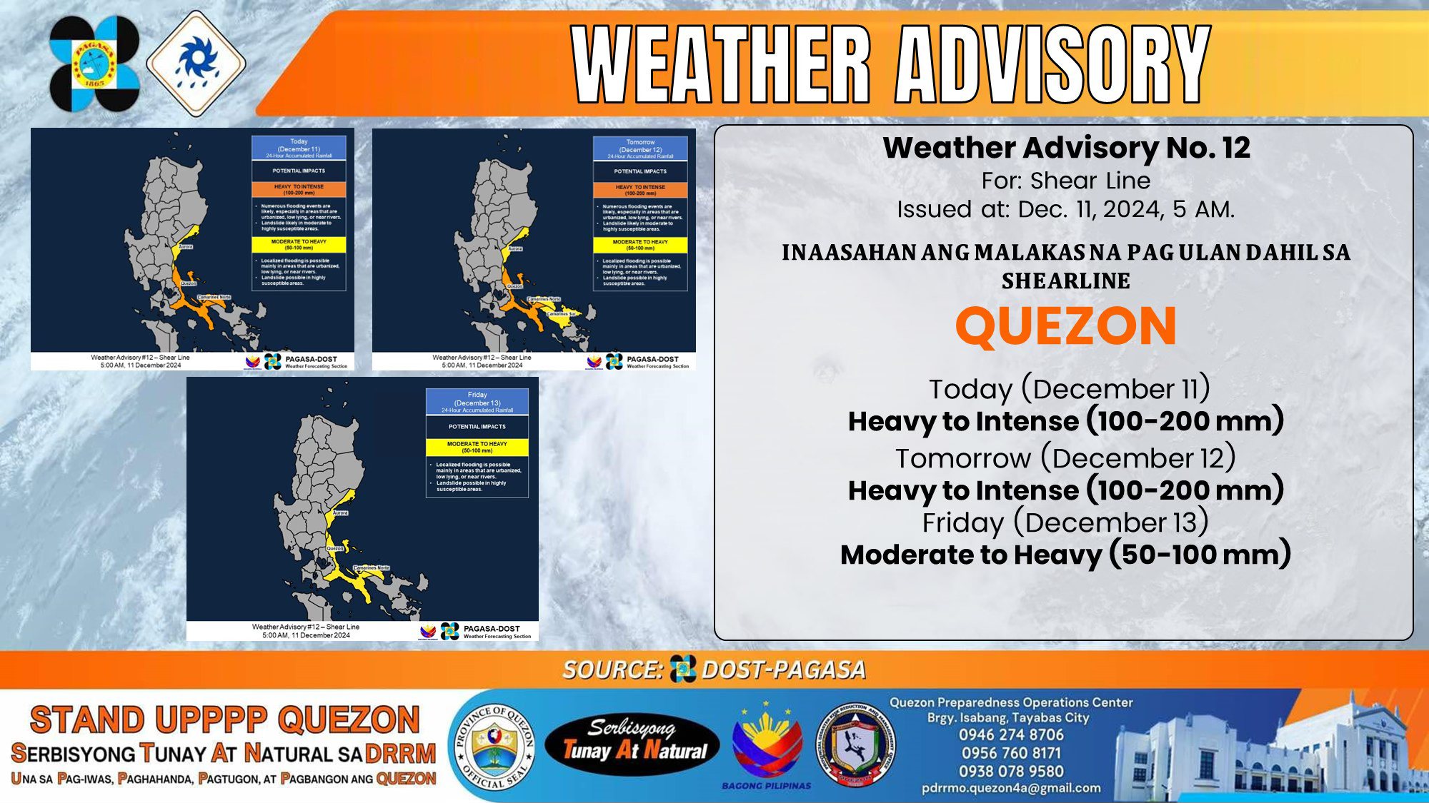
𝐈𝐍𝐀𝐀𝐒𝐀𝐇𝐀𝐍 𝐀𝐍𝐆 𝐌𝐀𝐋𝐀𝐊𝐀𝐒 𝐍𝐀 𝐏𝐀𝐆 𝐔𝐋𝐀𝐍 𝐃𝐀𝐇𝐈𝐋 𝐒𝐀 𝐒𝐇𝐄𝐀𝐑𝐋𝐈𝐍𝐄
𝗤𝗨𝗘𝗭𝗢𝗡:
Ngayon (December 11)
![]() 𝗛𝗲𝗮𝘃𝘆 𝘁𝗼 𝗜𝗻𝘁𝗲𝗻𝘀𝗲 (𝟭𝟬𝟬-𝟮𝟬𝟬 𝗺𝗺)
𝗛𝗲𝗮𝘃𝘆 𝘁𝗼 𝗜𝗻𝘁𝗲𝗻𝘀𝗲 (𝟭𝟬𝟬-𝟮𝟬𝟬 𝗺𝗺)
Huwebes (December 12)
![]() 𝗛𝗲𝗮𝘃𝘆 𝘁𝗼 𝗜𝗻𝘁𝗲𝗻𝘀𝗲 (𝟭𝟬𝟬-𝟮𝟬𝟬 𝗺𝗺)
𝗛𝗲𝗮𝘃𝘆 𝘁𝗼 𝗜𝗻𝘁𝗲𝗻𝘀𝗲 (𝟭𝟬𝟬-𝟮𝟬𝟬 𝗺𝗺)
Biyernes (December 13)
![]() 𝗠𝗼𝗱𝗲𝗿𝗮𝘁𝗲 𝘁𝗼 𝗛𝗲𝗮𝘃𝘆 (𝟱𝟬-𝟭𝟬𝟬 𝗺𝗺)
𝗠𝗼𝗱𝗲𝗿𝗮𝘁𝗲 𝘁𝗼 𝗛𝗲𝗮𝘃𝘆 (𝟱𝟬-𝟭𝟬𝟬 𝗺𝗺)
Ang inaasahang pag-ulan ay maaaring mas malakas sa mga bundok at mataas na lugar. Bukod dito, ang mga epekto sa ilang lugar ay maaaring lumala dahil sa malaking dami ng naunang pag-ulan.
Ang publiko at mga Tanggapan ng Pamamahala at Pagpapababa ng Bantang Panganib at Sakuna ay pinapayuhan na gawin ang kinakailangang hakbang upang protektahan ang buhay at ari-arian ng kanilang nasasakupan.
Maliban na lamang kung may malaking pagbabago, ang susunod na Weather Advisory ay ilalabas sa ganap na 11:00 AM mamaya.
Quezon PIO